I ran out of time (again). There were too many changes needed in the dissertation in order to make it acceptable for my committee, and not enough time to complete them. I am taking some time off from this research, but will be back next year. I would like to turn the research into a …
A new argument, a new focus, a new chapter.
It’s kind of late in the game, but at least I’m here. I’ll skip all the dramatic events from the past few months, and just say, I have two more months to finish edits to this dissertation. I was forced to realize that my previous itteration of the dissertation did not have a clear historical …
A week in the life of writing a dissertation
I recently had a whole week to work on my dissertation. Each day I wrote my thoughts at the beginning of the day and a short To Do list. I thought I would share as it is a small glimpse into the process of writing a large scholarly work. Monday, July 11, 2016 Today I …
Dissertation is live and on line
I am in the final stages of editing… hopefully. The plan is to finish this summer, defend in September, and graduate in December 2016. Now that I have all of the chapters written, and they just need some work (apparently lots and lots of work), I have put the text and images online in their …
The Writing Stack: Zotero -> Scrivener -> ODT -> Docx -> Markdown -> HTML
Scrivener to Markdown and HTML How to write in Scrivener and display in HTML, Markdown, ODT, or Doc and keep the footnotes and images. This is the process I use for getting my chapters out of Scrivener and formatted into Markdown and HTML for putting on the web. Markdown for Github, and HTML for a …
Locating WW2 map coordinates
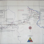
I was looking through some after action reports from the U.S. military groups that entered the Minden, Porta Westfalica area in early April 1945. The reports come from 5ad.org, an unofficial site dedicated to the 5th Armored Division in WW2, and the Combined Arms Research Digital Library (http://cgsc.contentdm.oclc.org/cdm/landingpage/collection/p4013coll8). The best find so far was the …
Methodology of a visualization
Introduction Visual representations of data offer a quick way to express a lot of information. As the old adage goes, a picture is worth a thousand words. One of the facets of digital humanities research is providing information in the form of visuals: graphs, maps, charts, etc. I was already writing up some notes on …
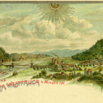
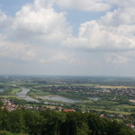
70 Year Commemoration at Porta Westfalica
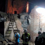
During May 5-10, I was once again in Porta Westfalica, Germany. The town of Porta Westfalica held a 70 year anniversary commemoration event, in honor of those who were slave laborers there during World War II, and especially those who died under the extreme and inhumane conditions. May 5, 2015 Despite striking train workers, I …
Looking at the data
I presented the following at the Association of American Geographers Annual meeting on April 21, 2015. I titled the presentation, “Placing Space in the Experiences of Forced Laborers at Porta Westfalica” What follows is the paper with the images I used in the presentation. This will turn into the presentation I’ll give in Porta Westfalica on …
Designing the Website
There are many, many, many, many web sites, tutorials, how-tos and printed pages written on how to create a website; the proper steps needed, the best way to design, the best place for hosting, and on and on. Well, here’s another one… Hopefully this reaches a different audience and provides insight and help along the way. Additionally, this …